The Portuguese Way is one of the most popular itineraries of the Camino de Santiago. After its beginning in the south of Portugal and passing through the cities of Lisbon and Porto, this Portuguese road enters Galicia through the municipality of Tui. There is also a variant of this traditional route along the coast that starts from the city of Porto and enters Galicia through the mouth of the river Miño, in A Guarda, and later in the town of Baiona. From Redondela, both routes join towards the city of Pontevedra.
During the Middle Ages the Portuguese Way began to develop thanks to ancient Roman roads. After the independence of the kingdom of Portugal from Castile, Queen Isabella of Portugal decided to undertake her pilgrimage to Santiago through the Portuguese Way in the 14th century. In addition to her journey, key to consolidate this itinerary, the queen allocated an important economic allocation for the maintenance of the pilgrims’ hospitals. Other nobles and monarchs would later follow the Portuguese Way, such as the Portuguese King Manuel I, in 1502, or the Grand Duke Cosimo III de Medicis, in 1669.
The popularity and rise of this road led to the appearance of numerous inns, hostels and pilgrim hospitals on the roads between Lisbon and Compostela, documented in the 15th and 16th centuries.
There is also a spiritual variant of the Camino de Santiago that connects the Portuguese Route with the Traslatio route, also known as the Mar de Arousa and the Ulla River route, a route that according to tradition the disciples of the Apostle followed with their remains on the way to Santiago going up the Ulla riverbed to Iria Flavia, Padrón.

Pontevedra, the capital of the Portuguese Route
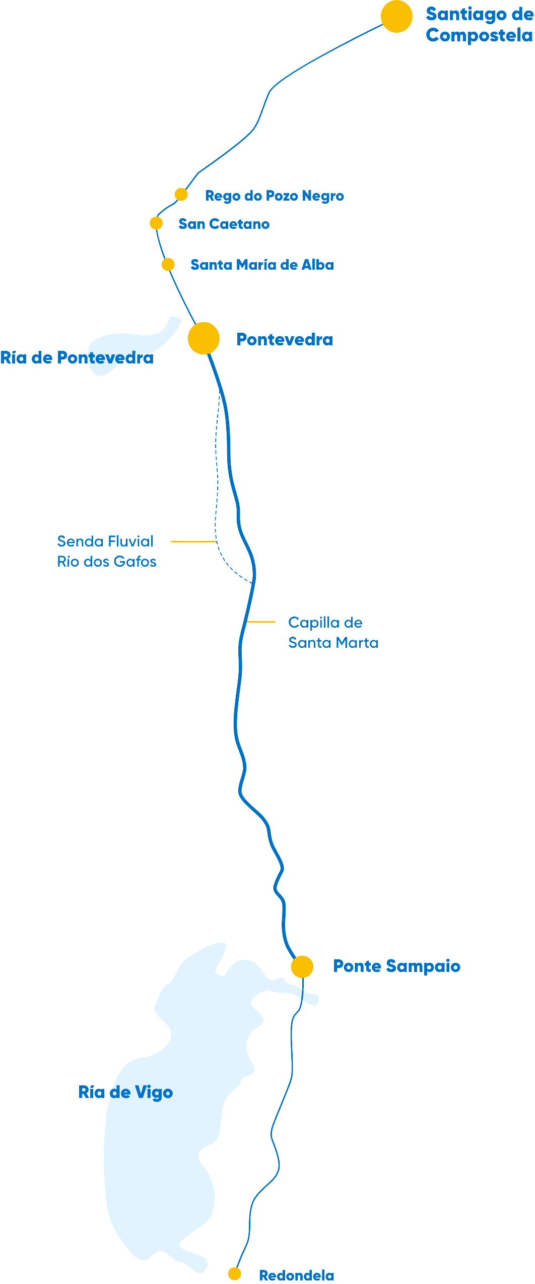
Pontevedra is the end of the stage for pilgrims who follow the route from Redondela, and the start for those who continue on to Caldas de Reis. The entrance of the Portuguese Way to the municipality is through the bridge of Ponte Sampaio at the mouth of the river Verdugo. This bridge of medieval origin, renovated in the 16th and 17th centuries, is famous for having been the scene of the last battle in Galicia against Napoleon’s army during the War of Independence. In this environment of great natural value is the islet Medal, which can be accessed on foot and enjoy several hiking trails.

Brea Vella from Canicouva
Gafos river section
After leaving Ponte Sampaio, the route then goes to Ponte Nova and then enters the Brea Vella da Canicouva, a path of just over 1 km of large slabs that runs along the route of the 19th century Roman road. This section of the Way between Pontesampaio, A Canicouva and the entrance to the municipality of Vilaboa is the one that keeps the most charm of the entire stage and houses the Chapel of Santa Marta (1617).
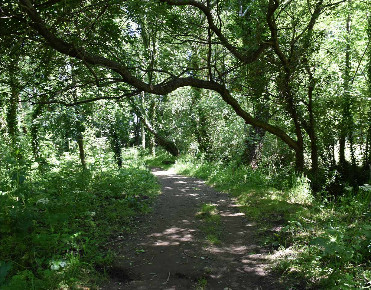
Again in the municipality of Pontevedra, two milestones guide the walkers towards the centre of the city of Pontevedra offering two alternatives, the Tomeza route or the natural path of the river Gafos, the latter has a lot of charm but it is neither accessible for wheelchairs nor is it recommended to go by bicycle due to the abundance of tree roots, it is not advisable to go on foot in the rainy season due to the mud and water accumulated on the road.
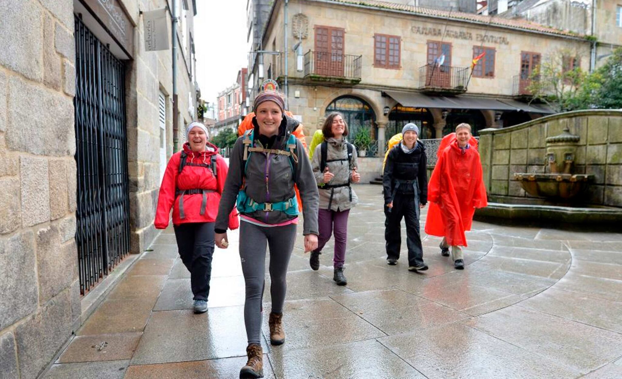
A pilgrims’ hostel is located at the entrance to the city, and very close by, Gorgullón street, extends the offer of hostels and hostels. The urban section of the Way of St. James, illuminated with lavender lights, becomes a pleasant walk through the most emblematic streets and squares of Pontevedra. You will hardly find vehicles thanks to the pedestrian city model Pontevedra has opted for.
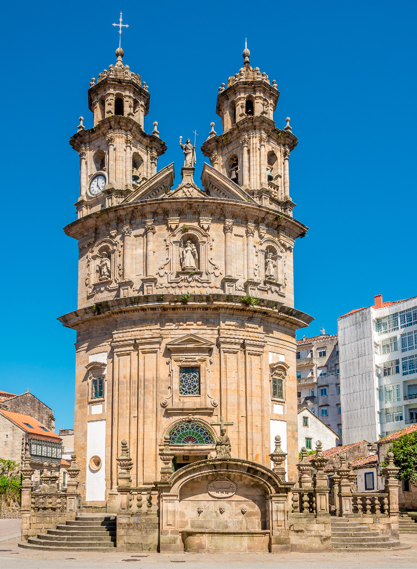
Next, in Virgen del Camino street, a structure with the number 64,500 indicates the distance to Santiago. Further on, a sculpture by Manuel Collazo and Manuel Fandiño, consisting of a fountain and a phrase that reads “Pontevedra é boa vila e da de beber a quen pasa” (Pontevedra is a good town and gives drink to those who pass by) welcomes the Glorieta de Compostela (Compostela Roundabout). At this point, the route continues along Peregrina street, where the famous sanctuary of the same name is located, one of the symbols of the city and a great protagonist of the Portuguese Way.
Peregrina Virgin Sanctuary
This temple from the end of the 18th century shelters the Patron Saint of the province and of the Portuguese Way to Santiago. The most curious thing about this sanctuary is its plant in the shape of a scallop shell, symbol of the Way of St. James and the pilgrims. On the outside three images represent the Virgin, St. James and St. Joseph with the clothes of the pilgrims. At the entrance there is a giant natural shell for the holy water, a gift from the admiral from Pontevedra, Casto Méndez Núñez, brought from the Pacific, in gratitude for his victory in the battle of Mindanao (1861). The current image of the Virgin is from 1867, the work of the Catalan sculptor Luis Vermell and the figure of the Child is by Gambino, from 1814. On the second weekend of August, the festivities in honour of the Pilgrim Virgin begin to be celebrated in the city and last for 10 days.
The walk continues!
From the Plaza de la Peregrina, the nerve centre of the city, the view of the sanctuary is magnificent. From this square we enter the historic centre of Pontevedra. The first important site that we find is the Plaza de la Herrería with its gardens in the upper part, where we find the famous Fuente de la Herrería: the one that, according to the song, gives water to those who pass by. Presiding over the gardens is the church of San Francisco built between 1310 and 1360, at that time still outside the perimeter of the city walls. The path continues along the street of arcades towards the Plaza de Curros Enríquez, and from here, the Calle Real leads to the River Lérez, where the Burgo Bridge is located.

The history of Pontevedra is inseparably linked to this bridge. Its old Roman remains gave the city its name as Ponte Veteri (old bridge), it is a symbol of Pontevedra and its coat of arms. The bridge was built by the Roman troops to save the river Lérez on the way XIX one of its main communication routes, this bridge had to be rebuilt in the 12th century and no remains of the Roman bridge have been found until today. On the other side of the bridge, on the corner of Xoan Manuel Pintos street, we find a cross known as the cross of Santiago Pilgrim, which dates back to the XVI-XVIII centuries. This cruceiro has sculpted the figure of the coat of arms of Santiago and a scallop and the Pontevedra coat of arms in wrought iron and belonged to the old chapel of Santiaguiño do Burgo, located nowadays behind the sports pavilion. The image of Santiago that presides over the 19th century altar of this temple that preserves its old facade embedded in the current concrete one.
To continue with the route, it is necessary to continue along Santiña street, whose name refers to the “Rainha Santa Doña Isabel” who decided, in 1325, to make a pilgrimage to Santiago, probably following this Portuguese way. In the number 95 of this street they take 6 generations receiving the image of Santiaguiño do Burgo that presides over the chapel. Tradition says that the Apostle was treated here when he made a pilgrimage to Compostela. He found himself tired during the trip and in that dwelling they gave him shelter and maintenance until he recovered. The saint promised that the first grapes and corn of each harvest would ripen in this house every year, and every year the family that owns the house makes an offering. At the end of the street there is a rural landscape and the Alba marshes, a wetland of 80 hectares that is home to a great variety of plant and bird species. In the parish of Santa María de Alba, in Pontevedra, we find its 12th century Romanesque church, presided over by a stone cross with the image of St. James the Pilgrim.
We are already in the final part of the road as it passes through the municipality of Pontevedra, we find the chapel of San Caetano, in Baroque style and built in the 17th century. We continue through the Pontevedra parish of Cerponzóns and the surroundings of Rego do Pozo Negro to enter the municipality of Barro.